
Tyumen Petroleum Research Center, OOO
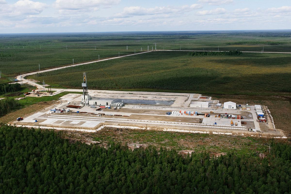
Tyumen Petroleum Research Center (TNNC), OOO, is the fundamental corporate research and design institute of Rosneft, PAO, performs field engineering and desktop support for the processes of geological studies and exploration, as well as for oil and gas deposits development of the Company's subsidiary oil and gas companies in Russia (Ural-Volga region, Western and Eastern Siberia, Sakhalin Island) and abroad (Vietnam, Venezuela, Brazil, Kurdistan, Egypt). TNNC supports over 90% of free gas production and 34% of the Company's oil production.
One of the key areas of TNNC, OOO activity is geological exploration: regional and local basin geology research from assessing oil and gas potential (basin modeling) to the localisation of reservoirs of various sizes, design and support of seismic exploration, processing and interpretation of seismic data, support for exploration drilling. From a geographical perspective, geological exploration is carried out in licensed areas of three large oil-bearing basins of Russia (Western and Eastern Siberia, Timan-Pechora Basin).
Among the innovative directions developed by the geological exploration unit there is the development and widespread use of stochastic inversion of seismic data, which allows not only to reduce the uncertainties in the predictions of the lithological structure of oil reservoirs and assess the degree of uncertainty of these predictions, but also to construct accurate three-dimensional digital geological models of pay beds.
In addition to developing innovative solutions in the field of seismic data interpretation technology, one of the key priorities of the Rosneft oil company is to increase the resource base of hydrocarbons in the areas of large oil and gas basins in Russia (West Siberian and Timan-Pechora oil and gas basins, Eastern Siberia). In addition to developing hydrocarbon reserves concentrated in the main pay bed of the West Siberian oil and gas Basin and in sediments of Eastern Siberia, the company plans to develop new stratigraphic intervals, which were previously considered unpromising or having little promise. For example, in the south and southwestern periphery of the West Siberian Basin, objects in the upper part of the pre-Jurassic formation are becoming more interesting. In the central regions, the Upper Jurassic oil and gas play as part of the Bazheno-Abalak play is beginning to actively develop. In the northern regions, new discoveries are associated with large deposits in the supra-cenomanian Upper Cretaceous play: Kuznetsovskaya, Berezovskaya and Gankinskaya formations, where, according to experts of TNNC, OOO, 1 billion m3 to 1.5 billion m3 of gas is concentrated. The replacement of hydrocarbon reserves on the territory of the Botuobinsky petroleum region of the East Siberian Basin, is going to be carried out with the development of new promising objects in the Ustun, Kursk and Verkhnebuk formations of the Upper Vendian.
Use of stochastic seismic inversion for lithology prediction in the interval of the Bazheno-Abalak play at the Krasnoleninsky arch
The problem of oil and gas potential in the Bazhenov and Abalak formations within the Krasnoleninsky arch is one of the most acute problems associated with hard-to-recover reserves of Western Siberia. On the one hand, high-rate oil inflows were obtained from these deposits in many wells, and on the other hand, the success rate of exploratory drilling at the Bazhenov-Abalak section interval is still very low. The reason for this is the significant uncertainty in the lithological composition of the considered formations.
Currently, one of the main methods for reducing the uncertainty of the lithological structure of oil and gas reservoirs is stochastic inversion of seismic data. It is a geological simulation, consistent with borehole and seismic data:
-
The resulting model has geological limitations defined by the probability-density functions of the distribution of lithotypes in the field of elastic parameters;
-
Alignment with seismic data is ensured through an iterative procedure, that inculdes the calculation of the synthetic wavefield according to the model and its comparison with the observed wavefield.
As a result of stochastic inversion, many equally probable implemantations of cubes of elastic properties, lithology, and reservoir porosity and permeability parameters are obtained, with vertical resolution comparable to the scale of the borehole survey. The fact that there are several implementations allows to assess the degree of uncertainty of the obtained predictions.
The presented results of stochastic seismic inversion are part of a large project for predicting the oil and gas potential of the Bazheno-Abalak play (BAP) within the Krasnoleninsky arch, in which specialists from various research centers are involved. Considerable work has been done on core sample research, as well as petrophysical and petro-elastic modeling, fracture characterisation, conceptual modeling, processing and interpretation of seismic data, which became the basis for stochastic seismic modeling and later served as the basis for constructing a 3D geological model.
One of the key issues in interpreting the results of stochastic inversion is the choice of implementations that are most appropriate for the studied object. In our case, the selection criterion was the standard deviation of the reservoir thickness prediction error in blind boreholes (boreholes evenly distributed over the area and not used in the calculation of the inversion due to incomplete borehole logging) for each implementation. The minimum error was noted in 8 implementations (Figure 1).
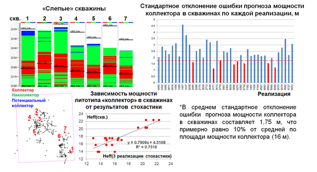
Figure 1. Selection of the most probable implementations by blind boreholes
|
Blind boreholes |
Слепые скважины |
|
Standard deviation of the prediction error of reservoir thickness in boreholes for each implementation, m |
Стандартное отклонение ошибки прогноза мощности коллектора в скважинах по каждой реализации, м |
|
Reservoir |
Коллектор |
|
Non-reservoir (tight rocks) |
Неколлектор |
|
Potential reservoir |
Потенциальный коллектор |
|
Dependence of the reservoir lithotype thickness in boreholes on stochastic results |
Зависимость мощности логотипа «коллектор» в скважинах от результатов стохастики |
|
*The average standard deviation of the prediction error of reservoir thickness in boreholes is 1.75 m, which is approximately 10% of the average reservoir thickness over the area (16 m). |
*В среднем стандартное отклонение ошибки прогноза мощности коллектора в скважинах составляет 1,75 м, что примерно равно 10% от средней по площади мощности коллектора (16 м). |
|
Implementation |
Реализация |
|
Heff (borehole) |
Heff(скв.) |
|
Heff (3 stochastic implementations) |
Heff(3 реализации стохастики) |
An assessment of the predicted reservoir capacity for all implementations was also performed. The difference between the minimum and maximum options is very small – therefore, the obtained implementations are stable. Based on the histogram of the reservoir thickness distribution, the implementations corresponding to the average values are selected (Figure 2). Three of them were selected that satisfy both selection criteria (blind boreholes and reservoir capacity).
Based on the results of stochastic seismic inversion, it was possible to predict the lithological properties of the object, as well as to identify productive and promising zones in the BAP interval and to assess the degree of prediction uncertainty. It should be noted that the prediction of properties (reservoir lithotype thickness, fracture density, carbonate thickness, brittleness, organic carbon content) based on the results of a previously performed deterministic inversion, the vertical resolution of which is comparable to the seismic, turned out to be insufficient for constructing a 3D geological model, because it was characterised by unsatisfactory correlation coefficients with borehole data. On the contrary, stochastic inversion made it possible to achieve stable correlation with borehole data.
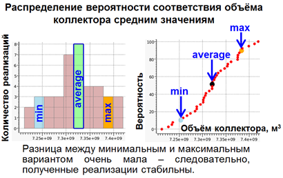
Figure 2. Selection of the most probable implementations by reservoir capacity
|
The distribution of probability of the reservoir capacity correspondence to the average values |
Распределение вероятности соответствия объема коллектора средним значениям |
|
Number of implementations |
Количество реализаций |
|
Probability |
Вероятность |
|
Resevoir capacity, m3 |
Объем коллектора, м3 |
|
The difference between the minimum and maximum options is very small – therefore, the obtained implementations are stable. |
Разница между минимальным и максимальным вариантом очень мала – следовательно, полученные реализации стабильны. |
The three-dimensional digital geological model of the Bazhenov and Abalak formations created on the basis of stochastic inversion data in the study area became the foundation for developing a further exploration strategy.
The potential growth of gas resources of the supra-cenomanian play in Western Siberia
Contemporary view suggests that the Upper Cretaceous strata above the Cenomanian is a strata composed of alternating seals and reservoirs (Figure 1).
The presence of regionally distributed fine-dispersed clays with contrasting acoustic properties allows to confidently distinguish four seismic sequences (SS) in the Cretaceous supra-cenomanian deposits. The same clays act as regional seals (Figure 2).
The structure of the lowest seismic sequence OГ Г – C4 of the Turonian age includes a single sandy-aleuritic reservoir of the Gaz-Salinskaya unit and Ipatovo formation. Seal – Markhinskaya unit (Figure 3)
Above the section, the seismic sequence ОГ C4-C3 (Coniacian-Santonian) is distinguished, including the Nizhneberezovskaya sub-formation and its stratigraphical analogues: the Nizhnechasselskaya sub-formation and the lower part of the Slavgorod formation. The reservoir is special because of its non-conventional type of reservoir – gaize and opoka clay. Seal – lower part of the Verkhneberezovskaya subformation.
The next seismic sequence OГ С3-C2 (the Campanian) is represented in the section by sediments of the Verkhneberezovskaya formation and its analogues: Verkhnechasselskaya formation and the upper part of the Slavgorod formation. The prospects of the gas potential of the sequence are connected to the appearance of reservoirs in the middle of the sub-formation (bed VB1) under sanding in the north-east direction. Seal – upper part of the Verkhneberezovskaya subformation.
The seismic sequence ОГ C2-C1 (Maastrichtian) is confined to the Gankinsky horizon. In the central part, it is represented by clay marl of the Gankinsky formation. The appearance of reservoirs is associated with an increase in sediment thickness in the northeast direction and clay replacement with aleurolites, starting from the top. Seal is the clays of the lower part of the Talitsky (Tibeysalinsky) formation.
Structural imaging was completed for each SS, shale lines of reservoirs and sanding lines of regional seals were mapped.
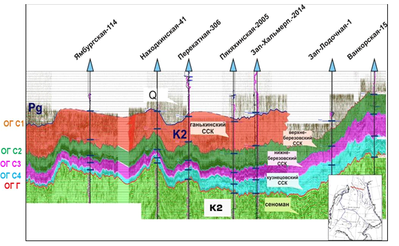
Figure 1. Seismic section of the Upper Cretaceous sediments in the northern part of the West Siberian basin
|
Yamburgskaya-114 |
Ямбургская-114 |
|
Nakhodkinskaya-41 |
Находкинская-41 |
|
Perekatnaya-306 |
Перекатная-306 |
|
Pyakyakhinskaya-2005 |
Пякяхинская-2005 |
|
Zap-Khalmerp.-2014 |
Зап-Хальмерп.-2014 |
|
Zap-Lodochnaya-1 |
Зап-Лодочная-1 |
|
Vankorskaya-15 |
Ванкорская-15 |
|
Gankinsky SS |
Ганькинский СКК |
|
Verkhne-Berezovsky SS |
Верхне-Березовский СКК |
|
Nizhne-Berezovsky SS |
Нижне-Березовский СКК |
|
Kuznetsovsky SS |
Кузнецовский СКК |
|
Cenomanian |
Сеноман |
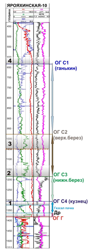
Figure 2. The structure of the Upper Cretaceous deposits, Yaroyahinskaya-10 well as an example
(regional seals are in grey)
|
Yaroyahinskaya-10 |
Ярояхинская-10 |
|
ОГ С1 (Gankinsky) |
ОГ С1 (ганькин) |
|
ОГ С2 (Verkhneberez.) |
ОГ С2 (верх.берез) |
|
ОГ С3 (Nizhne-Berez.) |
ОГ С3 (нижн.берез) |
|
ОГ С4 (Kuznets.) |
ОГ С4 (кузнец) |
|
Gaz-Sal. unit |
Газсал пачка |
|
Other |
Др |
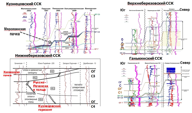
Figure 3. The concept structure of each sequenсe of Upper Cretaceous deposits
|
Kuznetsovsky SS |
Кузнецовский СКК |
|
Maloyamalskaya-3002 |
Малоямальская-3002 |
|
Parusnaya-1007 |
Парусная-1007 |
|
Pyakyakhinskaya-2005 |
Пякяхинская-2005 |
|
Khalmerpayutinskaya-2099 |
Хальмерпаютинская-2099 |
|
Vankorskaya-15 |
Ванкорская-15 |
|
Verkhneberezovsky SS |
Верхнеберезовский СКК |
|
PS |
ПС |
|
KZS |
КЗС |
|
GK |
ГК |
|
Nizhne-Berezovskaya formation |
Нижне-березовская свита |
|
Gaz-Salinskaya unit |
Газсалинская пачка |
|
Massonovskaya formation |
Массоновская свита |
|
Dorozhkovskaya formation |
Дорожковская свита |
|
Bichinskaya-1 |
Бичинская-1 |
|
Yuzhno-Pyreynaya-205 |
Южно-Пырейная – 205 |
|
Zapadno-Lodochnaya-1 |
Западно-Лодочная 1 |
|
Deryabinskaya-10 |
Дерябинская -10 |
|
Gaize and cherty silicites |
Опоки и кремнистые силициты |
|
Kheyakinskaya unit |
Хэякинская пачка |
|
Russko-Rechenskaya strata |
Русско-Реченская толща |
|
Clay gaize and opoka clay |
Глинистые опоки и опоковидные глины |
|
Sandy-aleuritic deposits |
Песчано-алевритовые отложения |
|
Kuznetsovsky horizon |
Кузнецовский горизонт |
|
Verkhneberezovsky SS |
Верхнеберезовский СКК |
|
South |
Юг |
|
Vostochno-Yelovaya-103 |
Восточно-Еловая-103 |
|
Kharampurskaya-362P |
Харампурская-362Р |
|
Zapadno-Khalmerparyutinskaya-201 |
Западно-Хальмерпарютинская-201 |
|
North |
Север |
|
Gankovsky SS |
Ганьковский СКК |
|
Permyakovskaya-53 |
Пермяковская-53 |
|
Verkhne-Chaselskaya-161 |
Верхне-Часельская-161 |
|
Severo-Solenimskaya-1 |
Северо-Соленимская-1 |
|
|
|
When zoning the prospects of structural traps of the sequences, common criteria were used (Figure 4):
Cenomanian sediment productivity (green outline)
At a depth of less than 350 m, deposits were not evaluated (deposits thinning, absence of selas – yellow outline).
The boundaries of the reservoir distribution, the termination of the tracking of regional seals;
The distribution of gas hydrates (east of the plain red line).
- Resource potential
assessment results:
Kuznetsovsky reservoir.
The state register of mineral reserves lists reserves in 14 deposits. All identified deposits are located in the area with the gas-bearing Cenomanian. Starting from the Messoyakha shaft and further north, deposits are favorable for the existence of gas hydrates. The resource potential is estimated at 1 trillion m3 in gas deposits and up to 1.5 trillion m3 in gas hydrate deposits.
Nizhneberezovsky reservoir
Current study phase.
The state register lists reserves at the Medvezhy and Kharampur deposits. The
total resource potential estimate is 5.5–9.5 trillion m3,
with up to
2 trillion m3 of gas in gas hydrate state.
Verkhneberezovsky reservoir
Relatively insignificant in size gas reserve in bed VB1. discovered at the Kharampur deposit. The gas inflow amounted to 40 thousand m3 / day.
The resource potential of the sequence is estimated at 1.3-2.7 trillion cubic meters, with more than 95% in the zone of gas hydrates stability.
Gankinsky reservoir
In the Gankinsky formation, gas shows are found in the Yamsoveyskaya, Verkhnerechenskaya, Gubkinsky and other fields. Producing zones are identified by electrical logging and confirmed by testing at the Gubkinsky deposit.
Gankinsky horizon resource potential is estimated at 1.5-2.5 trillion m3, with more than 95% of the resources in the zone of gas hydrates stability.

Figure 4. Structural Maps and Horizon Traps
a – Kuznetsovsky, b – Nizhneberezovsky,
v – Verkhneberezovsky, g – Gankinsky;
1, 2, 3, 4 – areas with different prospects of gas potential.
|
Structural traps in the Kuznetsov deposits interval |
Структурные ловушки в интервале кузнецовских отложений |
|
Structural traps in the Nizneberezovsky deposits interval |
Структурные ловушки в интервале нижнеберезенских отложений |
|
Structural traps in the Verkhneberezovsky deposits interval |
Структурные ловушки в интервале врехнеберезенских отложений |
|
Structural traps in the Gankinsky deposits interval |
Структурные ловушки в интервале ганькинских отложений |
New productive facilities in the Vendian sedimentary sequence of the Srednebotuobinsky deposit (Siberian platform)
Practice shows that at the late stage of exploration, significant hydrocarbon resources are detected in non-anticlinal type traps, which are often confined to geological bodies that were previously considered unproductive. The detection and mapping of such objects, characterised by a complex structure and, usually, by small size, is very difficult due to the lack of reliable search features. The conditions of paleotectonic and paleogeographic development of the territory of the Siberian Platform led to the formation of hydrocarbon traps of various genetic types associated with zones of stratigraphic and lithological thinning of productive deposits, with barrier reefs, with secondary reservoirs in carbonate strata, with hydrodynamic and capillary screens, gas hydrate zones.
New productive reservoirs.
In the course of exploration work carried out in recent years at the Srednebotuobinsky deposit, a number of previously unknown oil and gas objects were discovered. In such a way, a natural gas inflow with a flow rate of 200 thousand m3/day was obtained from the basal unit of the Ustunsky formation underlying the Preobrazhensky horizon. During testing a marking clay-carbonate unit of the Kursovskaya formation, which was previously considered unproductive, an oil inflow with stratum water was obtained with a flow rate of 18.7 m3/day. Signs of the existence of hydrocarbon traps are noted in the Verkhnebyukskaya subformation. The discovered hydrocarbon deposits structurally differ from those previously discovered within the Nepsko-Botuobinsky petroleum region, therefore, their further study is necessary.
Basal unit of the Uspunskaya formation.
The
productivity of the unit was first established in 2017 based on the results of
drilling a 115P borehole, in which an inflow of gas with a flow rate of more
than
200 thousand m3/day was obtained during the test.
The basal unit transgressively lies on the eroded surface of the Verkhnebyukskaya formation (predanilovsky stratigraphic unconformity). The bed is confined to the bottom of the Uspunskaya formation and is represented on most part of the area with clay-carbonate differentials. In the western part of the deposit, in the section of a number of wells, terrigenous, mainly clay deposits, probably representing the filling fascia of the incised valley, are noted. In the section of wells 115P and 94, the erosion channel is filled with quartz sandstone.
According to A.P. Vilesov interval of the basal horizon in well 115B corresponds to the stage of formation of the Nizhneuspunsky sequence. Deposits of the incised valley — channel sandstones and clay-aleuritic sediments of the floodland — lie at its bottom; they accumulated at the transgressive stage of the formation of the sequence. The incised valley formed at the low standing stage of relative sea level (LST). The terrigenous deposits of the channel filling overlap with the carbonates of the shallow sublittoral and littoral stages of the highstand of relative sea level.
As part of the interpretation of the seismic data, an AVA analysis was performed in the interval of the basal horizon, and the found result was that the thickness of the terrigenous part of the channel mainly affects the amplitude of reflection from this horizon. The spatial distribution of the terrigenous part is predicted by the exponential dependence of the total thickness of the basal horizon on the complex parameter FluidFactor, taking into account the parameters R0 (intercept) and G (gradient), with a correlation coefficient of 0.75. Then, according to the obtained dependence, a map of the total thickness of the basal horizon was calculated (Figure 1).
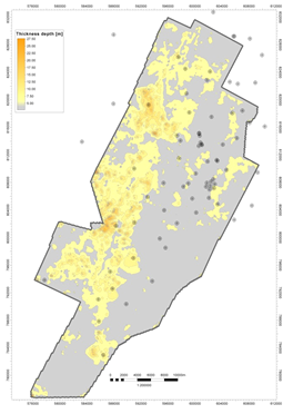
Figure 1. Map of the basal horizon total thickness
As a result of the prediction, a number of promising stratigraphic type traps associated with sandy deposits filling erosive channels were identified.
Arylakhsky horizon
According to the results of drilling exploratory well 110P in 2016, the productivity of a clay-carbonate unit was discovered in the upper part of the Kursovskaya formation. When testing this interval using clay-acid treatment, a mixed flow of oil and produced water was obtained with a flow rate of 18.7 m3/day. The bed was called Arylakhsky in honor of the unit of the same name, singled out by P.N. Kolosov as part of the Kursovskaya formation.
According to A.P. Vilesov and A.V. Plyusnina, the bed is formed by the alternation of dolomites, marls and mudstones. It is a bedding marker and is important for the correlation of sections of the Kursovskaya formation in the study area. Previously, the object was considered to have no signs of hydrocarbons.
The Arylakhsky horizon lies below the regional stratigraphic unconformity within the Kursovskaya formation (pre-Late Tyr erosion surface). The existence of this stratigraphic unconformity is justified in the work of Lebedev M.V., Moiseev S.A., Fomina A.M., etc. called "A stratigraphic diagram of Vendian terrigenous deposits of the northeast of the Nepsko-Botuobinsky anteclise."
During the period of pre-Late-Tyr erosion, the Nizhnepsky deposits, including the Arylakhsky horizon, eroded. The erosion intensity increased in the northwest direction, up to the complete denudation of individual stratigraphic levels (Figure 2).
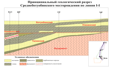
Figure 2. Principal geological section of the Kursovskaya formation of the Srednebotubinsky deposit
|
Principal geological section of the Srednebotuobinsky deposit along the I-I line |
|
|
Botoubinsky |
|
|
Ulakhansky |
|
|
Khamakinsky |
|
|
Arylakhsky |
|
|
Talakhsky |
|
|
Foundation |
|
|
Legend |
|
|
sandstone |
|
|
clay |
|
|
gravelstone |
|
|
foundation |
|
|
carbonate rock |
|
|
Unconformity surface |
|
The presence of a reservoir in the Arylakhsky horizon is presumably related to the processes of hypergenesis in the area where the rocks reach the erosive paleo-surface. In the core, taken from the Arylakhsky horizon immediately below the erosion paleo-surface (well 116R), interlayers of dolomite are unevenly cavernous-porous, non-uniformly oil saturated by fractures. The core taken in the zone not affected by paleohypergenesis is represented by mudstones and dense dolomites (well Krn 1).
According to the dynamic analysis data, the conditional lines of the beginning and complete erosion of the Arylakhsky horizon were mapped. Figure 3 shows a map of the total thicknesses, where the beginning of the bed resecting with the erosion surface is clearly visible – in the central part (purple line) and full thinning in the northwest (yellow line).
Figure 3. Map of the total thickness of the Arylakhsky horizon
Thus, the region of the likely occurrence of the reservoir in the Arylakhsky horizon can be contoured with the boundaries of the bed outcrop on the erosive paleo-surface (erosion area). The litho-stratigraphic traps associated with the Arylakhsky horizon are a new field of exploration in the area.
Verkhnebyukskaya subformation
Clay-sulphate-carbonate rocks of the upper part of the Byukskaya formation accordingly superpose the lower part, represented by sandstones of the Botuobinsky horizon. Earlier, deposits of the Verkhnebyuksky subformation within the Botuobinsky zone were considered unproductive. But according to the data of the history of the exploration of old exploratory wells, as well as the core data of new wells, there are clear signs of the existence of unexplored hydrocarbon deposits in this interval.
So while drilling exploratory well 18 in the middle part of the Verkhnebyuksky subformation, intensive absorption of drilling fluid up to 60 m3/h and abundant oil presence were noted. Based on well logging data, a bed reservoir with a porosity of up to 17% is clearly distinguished. With the passage of the described interval in well 86 an intense absorption with gas presence, which turned into controlled eruption, was recorded. Similar mud losses were also observed in well 5, located in the northern part of the deposit. According to core data from well 116P, lithogenetic fractures filled with bitumen are observed in dolomites of the lower part of the subformation.
The prospects of the Verkhnebyukskaya subformation are related to the fissure-cavernous type of the reservoir and are localised in the northern and central parts of the deposit.
Conclusion
Increasing the hydrocarbon resource potential is one of the key priorities of the Company. With the depletion of hydrocarbon reserves concentrated in the main reservoirs of the Srednebotuobinsky deposit, replenishment of hydrocarbon reserves is possible by connecting new promising facilities.
Hydrocarbon deposits similar to those discovered in the Uspunskaya, Byukskaya formations and the Arylakhsky horizon can also be found in other deposits of the Nepsko-Botuobinsky petroleum region. In this regard, the geological structure of the identified objects requires in-depth study.
Authors:
Agalakov Sergey Evgenyevich, Deputy Director General divisions on regional geology and geological exploration, Geological exploration management – North of Western Siberia Department of support of geological exploration in the Arctic regions, General Manager
Gaifullina Elena Fanisovna, Deputy Director General divisions on regional geology and geological exploration, Geological exploration management – Western Siberia Geological exploration support department – West Khanty-Mansi Autonomous Okrug, Chief Officer
Grischenko Marina Afanasyevna, Deputy Director General science divisions, Expert Analytical Management, Expert Department, Chief Expert
Novokreschin Aleksey Vasilyevich, Deputy Director General science divisions, Expert Analytical Management, Expert Department, Chief Expert
Novoselova Maya Yuryevna, Deputy Director General divisions on regional geology and geological exploration, Geological exploration management – North of Western Siberia, Department of support of geological exploration in the Arctic regions, Chief Officer
Torgashova Larisa Vitalyevna, Deputy Director General divisions on regional geology and geological exploration, Geological Exploration Management – New Projects and Eastern Siberia, Geological Exploration Support department in Eastern Siberia, Manager
Chikina Natalia Nikolaevna, Deputy Director General divisions on regional geology and geological exploration, Geological Exploration Management – New Projects and Eastern Siberia, Department of Geology and Seismic Interpretation, Petrophysics Expert
Rosneft

